A stream that is forgotten, underappreciated, and an
absolute gem. Swift Run popped on my
radar after our move to Greene County. At first glance, it looks like an
ordinary mountain stream within Shenandoah National Park but with an extreme
twist. Road Proximity! At its
closest point Route 33 is just a cobble stone throw away.
After exhaustive research through social media, websites,
and the VDGIF I concluded that the likelihood that Swift Run held a fishable
population of Native Brookies was extremely slim. So, I did the logical thing
and headed upstream so find out.
While the proximity of Swift Run to Route 33 seems convenient
in terms of parking and access; it actually can be a quite the challenge. Don’t
let that discourage you though, as it is an underutilized stream by local
fisherman. The only parking area is at the beginning of the National Park
Boundary on the left as you ascend the mountain. The GPS Coordinates are
located below for you to navigate to the parking area.
I first fished Swift Run on November 21st, 2018.
The water levels were high from recent rains and the water temperature was in
the high 40’s. I targeted deeper pools,
where still water conditions were present, as the higher flows made nymphing
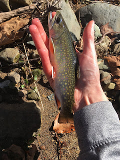
difficult. The first few holes produced five fish in rapid succession with the
largest Native being just over 9 inches. I fished it again in December, around Christmas,
and was rewarded with similar results.
 |
| Caught November 21st, 2018 |
 |
| Caught December 23rd, 2018 |
Ideal patterns seem
to be a small cream-colored mini mop fly or gold bead caddis pupa. I have also had great luck on small stonefly patterns.
Swift Run has steadily become one of my favorite streams for
a quick afternoon outing. If you check it out please practice catch and release
fishing, take care of the Brookies by wetting your hands and quickly returning
them to the water, and help clean up the parking area if you have time. Public
Lands are ours to enjoy so let’s help keep them beautiful for the next person!
GPS Coordinates
Latitude: 38°20'40.56"N
Longitude: 78°30'47.70"W
Gear Used
Orvis Battenkill 1
Orvis Hydros Fly Line
Maxcatch 1 Wt 6' Ultralight Fly Rod
Mini Mops (From Mossy Creek Fly Shop)
Caddis Patterns (Walmart)
Allen Sling Bag
Waders (You will need them to access portions of the stream)


Nice little trip report, and some pretty fish to boot. Now just don't go giving away all the good fishing spots, ok? :)
ReplyDeleteThere are a few too near and dear to my heart to ever post. I want to share spots because I often get asked for information but at the same time I fear the spots will get abused. I just hope that by giving people useful information they too as well will care for the spots and the fish as I do.
DeleteGreat content! I was thinking about doing this in a video format. Let me know if you ever want to do a collaboration.
ReplyDeleteHey, thanks for the comment. I would be very interested in getting together and doing a little filming. Shoot me an email at settle.kyle@gmail.com.
ReplyDelete